


 Rated as: n/a


 Cache attributes


 Description
An aquifer is an underground layer of water-bearing permeable rock, rock fractures or unconsolidated materials (gravel, sand, or silt) from which groundwater can be extracted using a water well. The study of water flow in aquifers and the characterization of aquifers is called hydrogeology.
Aquifers may occur at various depths. Those closer to the surface are not only more likely to be used for water supply and irrigation, but are also more likely to be topped up by the local rainfall. Many desert areas have limestone hills or mountains within them or close to them that can be exploited as groundwater resources. Parts of the Atlas Mountains in North Africa, the Lebanon and Anti-Lebanon ranges between Syria and Lebanon, the Jebel Akhdar (Oman) in Oman, parts of the Sierra Nevada and neighboring ranges in the United States' Southwest, have shallow aquifers that are exploited for their water. Overexploitation can lead to the exceeding of the practical sustained yield; i.e., more water is taken out than can be replenished. Along the coastlines of certain countries, such as Libya and Israel, increased water usage associated with population growth has caused a lowering of the water table and the subsequent contamination of the groundwater with saltwater from the sea.
The beach provides a model to help visualize an aquifer. If a hole is dug into the sand, very wet or saturated sand will be located at a shallow depth. This hole is a crude well, the wet sand represents an aquifer, and the level to which the water rises in this hole represents the water table.
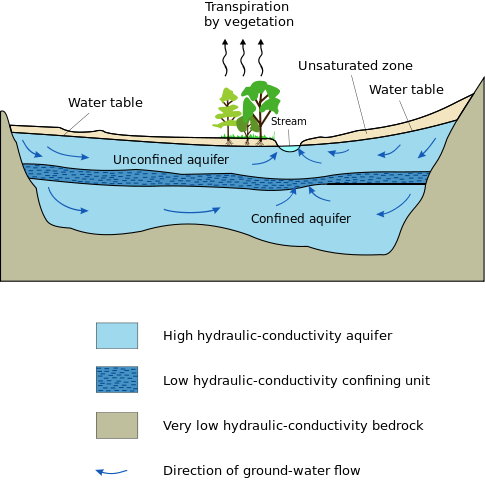
The above diagram indicates typical flow directions in a cross-sectional view of a simple confined or unconfined aquifer system. The system shows two aquifers with one aquitard (a confining or impermeable layer) between them, surrounded by the bedrock aquiclude, which is in contact with a gaining stream (typical in humid regions). The water table and unsaturated zone are also illustrated. An aquitard is a zone within the earth that restricts the flow of groundwater from one aquifer to another. An aquitard can sometimes, if completely impermeable, be called an aquiclude or aquifuge. Aquitards are composed of layers of either clay or non-porous rock with low hydraulic conductivity.
Classification
There are two end members in the spectrum of types of aquifers; confined and unconfined (with semi-confined being in between). Unconfined aquifers are sometimes also called water table or phreatic aquifers, because their upper boundary is the water table or phreatic surface. Typically (but not always) the shallowest aquifer at a given location is unconfined, meaning it does not have a confining layer (an aquitard or aquiclude) between it and the surface.
Confined aquifers have very low storativity values (much less than 0.01, and as little as 10−5), which means that the aquifer is storing water using the mechanisms of aquifer matrix expansion and the compressibility of water, which typically are both quite small quantities. Unconfined aquifers have storativities (typically then called specific yield) greater than 0.01 (1% of bulk volume); they release water from storage by the mechanism of actually draining the pores of the aquifer, releasing relatively large amounts of water (up to the drainable porosity of the aquifer material, or the minimum volumetric water content).
Human dependence on groundwater
Most land areas on Earth have some form of aquifer underlying them, sometimes at significant depths. In some cases, these aquifers are rapidly being depleted by the human population.
Fresh-water aquifers, especially those with limited recharge by snow or rain, also known as meteoric water, can be over-exploited and depending on the local hydrogeology, may draw in non-potable water or saltwater intrusion from hydraulically connected aquifers or surface water bodies. This can be a serious problem, especially in coastal areas and other areas where aquifer pumping is excessive. In some areas, the ground water can become contaminated by arsenic and other mineral poisons.
Aquifers are critically important in human habitation and agriculture. Deep aquifers in arid areas have long been water sources for irrigation (like the Ogallala aquifer in the US). Many villages and even large cities draw their water supply from wells in aquifers.
Aquifers that provide sustainable fresh groundwater to urban areas and for agricultural irrigation are typically close to the ground surface (within a couple of hundred metres) and have some recharge by fresh water. This recharge is typically from rivers or meteoric water (precipitation) that percolates into the aquifer through overlying unsaturated materials.
Occasionally, sedimentary or "fossil" aquifers are used to provide irrigation and drinking water to urban areas. In Libya, for example, Muammar Gaddafi's Great Manmade River project has pumped large amounts of groundwater from aquifers beneath the Sahara to populous areas near the coast. Though this has saved Libya money over the alternative, desalination, the aquifers are likely to run dry in 60 to 100 years. Aquifer depletion has been cited as one of the causes of the food price rises of 2011.
Piteşti city springs
Piteşti city lies near the boundary between the Getic plateau (to the north) and the Romania plain (to the south). Groundwater in the hilly area of the Getic plateau is usually found at depths of 100m or more, while in the plain, especially along the river medows, it lies at shallow depths.
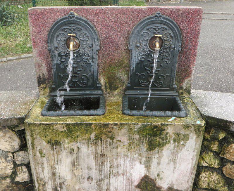 Piteşti municipality drilled a number of wells in the late 2000s and created a number of public fountains with the purpose of offering drinking water to it's citizens. Quite often people prefer the water from these deep underground sources (although they may contain additional sulphur or ammonia, giving the water a distinct taste) then the filtered river water available as tap water.
The springs run 24/7 with fairly constant flow and constant temperature. Access is free for everyone.
There are over 20 such springs, spread all over the city.
Health management office monitors the water quality and sometimes in summer it may happen that a few of the springs are declared unsafe for drinking (due to infiltration of contaminants, mostly bacteria that thrives in the hot weather). These notices are clearly displayed next to the spring.
Some feature fountains on both sides of the road, but it still is a single well, supplying both.
To log this cache:
Visit several springs within the city limits (waypoints provided below). Some are in the valley, some are on the hills. Read the information panel nearby. Using you GPS, determine the altitude. Taste the water (unless that spring was declared unsafe).
Answer the following questions in an email to the owner:
- why is there a significant difference of well depth between springs in the valley and springs on the hills?
- why isn't the difference [almost] identical to the altitude difference?
- why does the water taste differently?
If your answers are correct, the owner will send you by E-Mail the password required to log this cache.
A few of the springs are listed here (pick at least 2 from the valley and 2 from the hills):
- Bazar - N44° 51.456' E24° 52.676'
- Calea Bucureşti - N44° 51.828' E24° 52.610'
- Strada Crinului - N44° 51.540' E24° 52.550'
- Parcul Prundu - N44° 49.799' E24° 54.601'
- Zona industriala Găvana - N44° 52.965' E24° 49.926'
- Piaţa Smârdan - N44° 50.711' E24° 53.197'
- Zona Smeurei - N44° 51.266' E24° 51.852'
- Complex I Trivale - N44° 51.021' E24° 51.289'
- Războieni - N44° 50.445' E24° 52.601'
Note: on your quest you may also find geocaches nearby.
 Additional waypoints
| Symbol | Type | Coordinates | Description |
|---|---|---|---|

|
Virtual point | --- | Bazar |
|
|
Virtual point | --- | Calea Bucureşti |
|
|
Virtual point | --- | Strada Crinului |
|
|
Virtual point | --- | Parcul Prund |
|
|
Virtual point | --- | Zona industriala Găvana |
|
|
Virtual point | --- | Piaţa Smârdan |
|
|
Virtual point | --- | Zona Smeurei |
|
|
Virtual point | --- | Complex I Trivale |
|
|
Virtual point | --- | Războieni |
 Additional hints
 Log entries:
 0x
0x
 0x
0x
 1x
1x


