


 0x Gevonden
  0x Niet gevonden
  1 Opmerkingen
  0 Volgers
  Beoordeeld als: n/b


 Cache attributen


 Beschrijving
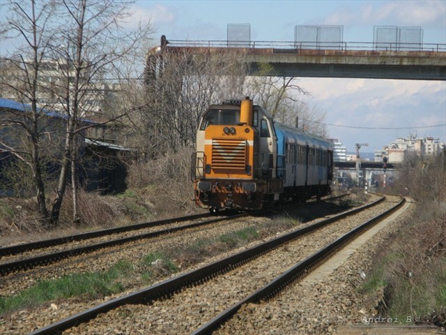
Piteşti is among the few cities in Romania where the railroad crosses the city, not only that, part of the way it uses a high embankment, thus allowing unhindered car and pedestrain traffic.
CFR Călători (Romanian Passenger Railway Company) runs connections to Bucureşti, Curtea de Argeş, Craiova, Câmpulung Muscel, Corbu, Slatina, Piatra Olt.
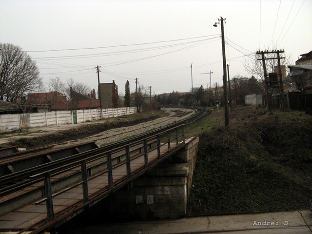
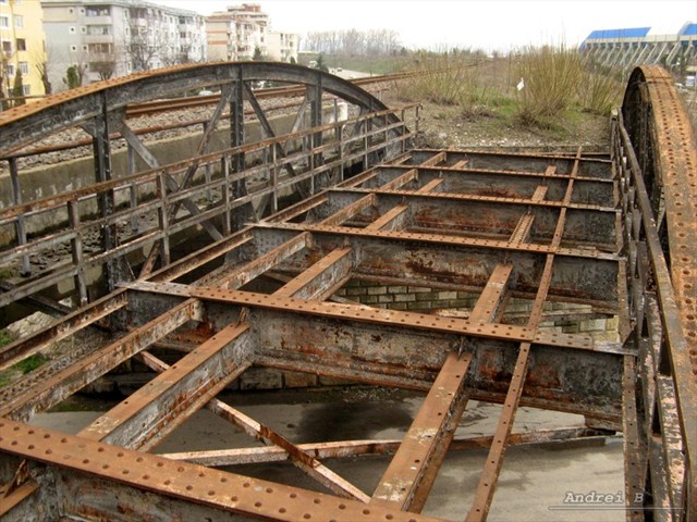 The railway was supposed to be double track across the city, however the second track was never finished. Today only part or the track bed and bridge skeletons can be seen.
Regardless, crossing the city by rail must be quite a pitoresque experience.
 Even if you did not come by rail, let's see it's route across Piteşti.
Clearly the trains have priority in traffic. No less then 8 bridges allow the track to cross the city.
Your journey will start at the first bridge and end at ...
- Bridge -1
N 44° 49.726' E 24° 56.109'
P=how many tracks cross this bridge? - Bridge 0 (ZERO)
N 44° 49.729' E 24° 55.172'
On the bridge pier it says xxA; P0=xx - Bridge 1
N 44 49.715 E 024 54.735
Between the tracks, SW end, there is an indicator; P1=number written with smaller font - Bridge 2
N 44 49.795 E 024 54.741
See indicator at the NE end; P2=number written with larger font - Bridge 3
N 44 51.036 E 024 52.915
Maximum height allowed for road vehicles to go under the bridge. See roadsign; P3=height (integer part) - Bridge 4
N 44 51.237 E 024 52.969
P4=how many transversal girders sustain the bridge? (without the ends) - Bridge 5
N 44 51.425 E 024 52.981
P5=how many longitudinal beams sustain this bridge? - Bridge 6
N 44 51.639 E 024 53.003
The old and abandoned truss bridge has it's beams riveted together. On top of the arch there is an additional metal plate, held also by rivets;
P6=how many rivets hold such a plate? - Bridge 7
N 44 51.758 E 024 52.947
Under the bridge you will find a plaque carved into the stone pier, with small squares carved into it, some of which may have an "X" marked with chalk;
P7=how many squares are there on the plaque? - Bridge 8
N 44 51.886 E 024 52.760
Coming from the city, there is a stone ladder at the NW end of the bridge. One may climb this ladder to the deck level;
P8=how many steps?
Magic: N44 --.--- E24 --.---N=P*P4*P8*P7*P5-P1*(P8-P3)-P5*P5*10-4E=P1*P2*P3+P0*P2*P3+P6*P4*(P5+1)+13
At some of the bridges you may also find a distinct geocache. Good luck!
Note: All information necessary to solve this puzzle can be found without the need to also find the geocaches present at (some of) the bridges.
Warning! Railway in use. Cale ferată circulată. Beware of the trains!
 OpenChecker
 Extra waypoints
| WP nummer | Symbool | Soort | Coördinaten | Beschrijving |
|---|---|---|---|---|
| 1 |

|
Virtueel punt | --- |
Podul -1 P=câte şine traversează acest pod? |
| 2 |
|
Virtueel punt | --- |
Podul 0 (ZERO) Pe piciorul podului scrie xxA; P0=xx |
| 3 |
|
Virtueel punt | --- |
Podul 1 Între şine, spre SV, se află un indicator; P1=numărul scris mai mic |
| 4 |
|
Virtueel punt | --- |
Podul 2 La capătul NE se află un indicator; P2=numărul scris mai mare |
| 5 |
|
Virtueel punt | --- |
Podul 3 Înălţimea maximă permisă pentru vehicule rutiere să treacă pe sub pod. Vezi indicator rutier; P3=înălţime (parte întreagă) |
| 6 |
|
Virtueel punt | --- |
Podul 4 P4=câte grinzi transversale susţin podul? (Fără capete) |
| 7 |
|
Virtueel punt | --- |
Podul 5 P5=câte grinzi longitudinale metalice susţin podul? |
| 8 |
|
Virtueel punt | --- |
Podul 6 Podul cel vechi, abandonat, este din grinzi metalice prinse cu nituri. Deasupra, pe fiecare parte, se află o placă de întărire, prinsă tot cu nituri; P6=câte nituri prind o astfel de placă? |
| 9 |
|
Virtueel punt | --- |
Podul 7 Sub pod, pe piciorul de piatră, găseşti o placa împărţită în pătrăţele, unele cu câte un "X" făcut cu creta; P7=câte pătrăţele se află pe placă? |
| 10 |
|
Virtueel punt | --- |
Podul 8 Dinspre oraş, la capătul NV, poţi urca pe nişte trepte de piatră, de la stradă până pe pod; P8=câte trepte? |
 Logs:
0x
0x
1x
Logs:
0x
0x
1x


